18/8/22

yappel
User

Length
14.6 km

Max alt
383 m

Uphill gradient
291 m
Km-Effort
18.5 km

Min alt
226 m

Downhill gradient
292 m
Boucle
Yes
Creation date :
2022-08-18 12:41:39.487
Updated on :
2022-08-18 16:17:07.923
3h31
Difficulty : Medium

FREE GPS app for hiking
 SityTrail
IGN / Geographical institutes
SityTrail Plus
The world is yours!
About
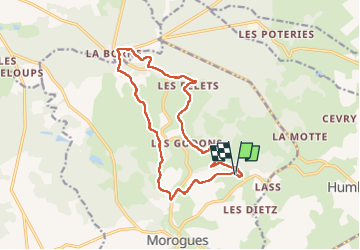
Trail Walking of 14.6 km to be discovered at Centre-Loire Valley, Cher, Morogues. This trail is proposed by yappel.
Description
LesFromions ~La Borne
Avec T, L, S, C
Positioning
Country:
France
Region :
Centre-Loire Valley
Department/Province :
Cher
Municipality :
Morogues
Location:
Unknown
Start:(Dec)
Start:(UTM)
471118 ; 5233733 (31T) N.
Comments