


Rifugio Stevia and Col dala Pieres Day Hike in Val Gardena

Bruno566
User
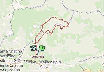

Length
14.1 km

Max alt
2747 m

Uphill gradient
1106 m
Km-Effort
29 km

Min alt
1709 m

Downhill gradient
1105 m
Boucle
Yes
Creation date :
2022-08-19 10:52:29.85
Updated on :
2022-08-19 10:53:17.134
6h33
Difficulty : Medium

FREE GPS app for hiking
 SityTrail
IGN / Geographical institutes
SityTrail Plus
The world is yours!
About
Trail Walking of 14.1 km to be discovered at Trentino-Alto Adige/Südtirol, South Tyrol, Sëlva - Wolkenstein - Selva di Val Gardena. This trail is proposed by Bruno566.
Positioning
Country:
Italy
Region :
Trentino-Alto Adige/Südtirol
Department/Province :
South Tyrol
Municipality :
Sëlva - Wolkenstein - Selva di Val Gardena
Location:
Unknown
Start:(Dec)
Start:(UTM)
711048 ; 5160379 (32T) N.
Comments