


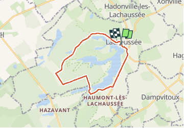
Étang Lachaussée

Jean ANDRE
User

Length
11.3 km

Max alt
238 m

Uphill gradient
98 m
Km-Effort
12.6 km

Min alt
207 m

Downhill gradient
96 m
Boucle
Yes
Creation date :
2022-08-19 12:52:47.676
Updated on :
2022-08-19 15:24:52.413
2h31
Difficulty : Medium

FREE GPS app for hiking
 SityTrail
IGN / Geographical institutes
SityTrail Plus
The world is yours!
About
Trail Walking of 11.3 km to be discovered at Grand Est, Meuse, Lachaussée. This trail is proposed by Jean ANDRE.
Description
Étang Lachaussée
Positioning
Country:
France
Region :
Grand Est
Department/Province :
Meuse
Municipality :
Lachaussée
Location:
Unknown
Start:(Dec)
Start:(UTM)
705837 ; 5435215 (31U) N.
Comments