


Jura 11

Pascal Bernaud
User

Length
23 km

Max alt
1413 m

Uphill gradient
340 m
Km-Effort
29 km

Min alt
932 m

Downhill gradient
756 m
Boucle
No
Creation date :
2022-08-19 06:07:45.0
Updated on :
2022-08-20 07:13:15.933
25h04
Difficulty : Very difficult

FREE GPS app for hiking
 SityTrail
IGN / Geographical institutes
SityTrail Plus
The world is yours!
About
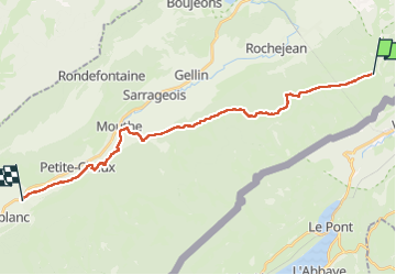
Trail Walking of 23 km to be discovered at Bourgogne-Franche-Comté, Doubs, Longevilles-Mont-d'Or. This trail is proposed by Pascal Bernaud.
Positioning
Country:
France
Region :
Bourgogne-Franche-Comté
Department/Province :
Doubs
Municipality :
Longevilles-Mont-d'Or
Location:
Unknown
Start:(Dec)
Start:(UTM)
297748 ; 5179004 (32T) N.
Comments