


Saint Mesmin

taguette
User
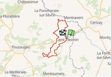

Length
26 km

Max alt
228 m

Uphill gradient
328 m
Km-Effort
30 km

Min alt
149 m

Downhill gradient
328 m
Boucle
Yes
Creation date :
2022-08-21 06:57:11.583
Updated on :
2022-08-21 13:37:43.433
6h19
Difficulty : Very difficult

FREE GPS app for hiking
 SityTrail
IGN / Geographical institutes
SityTrail Plus
The world is yours!
About
Trail Walking of 26 km to be discovered at Pays de la Loire, Vendée, Saint-Mesmin. This trail is proposed by taguette.
Positioning
Country:
France
Region :
Pays de la Loire
Department/Province :
Vendée
Municipality :
Saint-Mesmin
Location:
Unknown
Start:(Dec)
Start:(UTM)
673022 ; 5184809 (30T) N.
Comments