


Stationswandeling Mont-Saint-Guibert - Ottignies

FreddyTuerlinckx
User
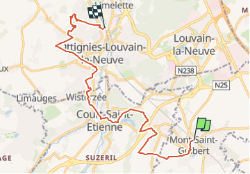

Length
14.6 km

Max alt
136 m

Uphill gradient
233 m
Km-Effort
17.8 km

Min alt
59 m

Downhill gradient
280 m
Boucle
No
Creation date :
2022-08-23 08:08:09.559
Updated on :
2024-06-04 06:12:22.959
4h02
Difficulty : Easy

FREE GPS app for hiking
 SityTrail
IGN / Geographical institutes
SityTrail Plus
The world is yours!
About
Trail On foot of 14.6 km to be discovered at Wallonia, Walloon Brabant, Mont-Saint-Guibert. This trail is proposed by FreddyTuerlinckx.
Positioning
Country:
Belgium
Region :
Wallonia
Department/Province :
Walloon Brabant
Municipality :
Mont-Saint-Guibert
Location:
Mont-Saint-Guibert
Start:(Dec)
Start:(UTM)
614046 ; 5610829 (31U) N.
Comments