


r mezilhac lachamp raphael montivernoux

07es18
User
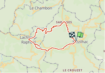

Length
16.2 km

Max alt
1430 m

Uphill gradient
702 m
Km-Effort
26 km

Min alt
771 m

Downhill gradient
702 m
Boucle
Yes
Creation date :
2022-08-23 07:15:25.077
Updated on :
2022-08-23 18:52:45.701
4h54
Difficulty : Medium

FREE GPS app for hiking
 SityTrail
IGN / Geographical institutes
SityTrail Plus
The world is yours!
About
Trail Walking of 16.2 km to be discovered at Auvergne-Rhône-Alpes, Ardèche, Mézilhac. This trail is proposed by 07es18.
Positioning
Country:
France
Region :
Auvergne-Rhône-Alpes
Department/Province :
Ardèche
Municipality :
Mézilhac
Location:
Unknown
Start:(Dec)
Start:(UTM)
606488 ; 4962550 (31T) N.
Comments