


lac de Vailhan

34christophe
User
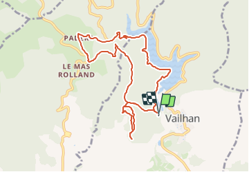

Length
10 km

Max alt
292 m

Uphill gradient
258 m
Km-Effort
13.4 km

Min alt
133 m

Downhill gradient
256 m
Boucle
Yes
Creation date :
2022-08-23 20:23:09.24
Updated on :
2023-08-19 17:10:03.758
3h02
Difficulty : Difficult

FREE GPS app for hiking
 SityTrail
IGN / Geographical institutes
SityTrail Plus
The world is yours!
About
Trail Walking of 10 km to be discovered at Occitania, Hérault, Vailhan. This trail is proposed by 34christophe.
Positioning
Country:
France
Region :
Occitania
Department/Province :
Hérault
Municipality :
Vailhan
Location:
Unknown
Start:(Dec)
Start:(UTM)
523948 ; 4822350 (31T) N.
Comments