


2408

maxEA65
User
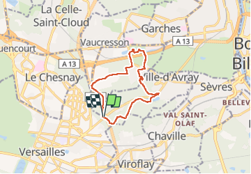

Length
10.9 km

Max alt
185 m

Uphill gradient
175 m
Km-Effort
13.3 km

Min alt
118 m

Downhill gradient
174 m
Boucle
Yes
Creation date :
2022-08-24 06:21:45.573
Updated on :
2022-08-24 09:00:23.542
2h37
Difficulty : Difficult

FREE GPS app for hiking
 SityTrail
IGN / Geographical institutes
SityTrail Plus
The world is yours!
About
Trail Walking of 10.9 km to be discovered at Ile-de-France, Hauts-de-Seine, Ville-d'Avray. This trail is proposed by maxEA65.
Positioning
Country:
France
Region :
Ile-de-France
Department/Province :
Hauts-de-Seine
Municipality :
Ville-d'Avray
Location:
Unknown
Start:(Dec)
Start:(UTM)
438148 ; 5407230 (31U) N.
Comments