


jenni 1

apa
User
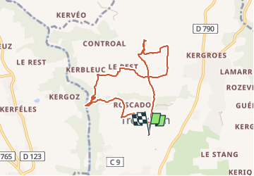

Length
8 km

Max alt
97 m

Uphill gradient
128 m
Km-Effort
9.7 km

Min alt
19 m

Downhill gradient
128 m
Boucle
Yes
Creation date :
2022-08-25 07:17:35.562
Updated on :
2022-08-25 08:14:49.921
56m
Difficulty : Medium

FREE GPS app for hiking
 SityTrail
IGN / Geographical institutes
SityTrail Plus
The world is yours!
About
Trail Running of 8 km to be discovered at Brittany, Finistère, Tréméven. This trail is proposed by apa.
Positioning
Country:
France
Region :
Brittany
Department/Province :
Finistère
Municipality :
Tréméven
Location:
Unknown
Start:(Dec)
Start:(UTM)
460190 ; 5304915 (30T) N.
Comments