


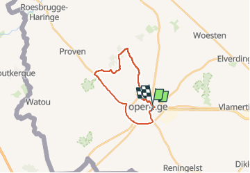
YSER 2022 Poperinge

patdecosnes
User

Length
17.4 km

Max alt
42 m

Uphill gradient
109 m
Km-Effort
18.9 km

Min alt
16 m

Downhill gradient
110 m
Boucle
No
Creation date :
2022-08-25 07:33:05.663
Updated on :
2022-08-25 13:14:56.159
5h40
Difficulty : Easy

FREE GPS app for hiking
 SityTrail
IGN / Geographical institutes
SityTrail Plus
The world is yours!
About
Trail Walking of 17.4 km to be discovered at Flanders, West Flanders, Poperinge. This trail is proposed by patdecosnes.
Positioning
Country:
Belgium
Region :
Flanders
Department/Province :
West Flanders
Municipality :
Poperinge
Location:
Poperinge
Start:(Dec)
Start:(UTM)
481191 ; 5633487 (31U) N.
Comments