


GR125 Namur-Franière

mozzipsc
User
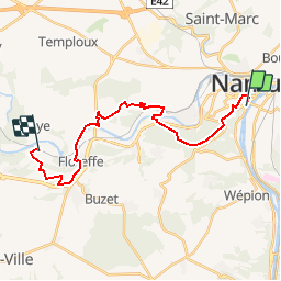

Length
19.4 km

Max alt
228 m

Uphill gradient
463 m
Km-Effort
26 km

Min alt
77 m

Downhill gradient
458 m
Boucle
No
Creation date :
2015-03-25 00:00:00.0
Updated on :
2015-03-25 00:00:00.0
5h25
Difficulty : Difficult

FREE GPS app for hiking
 SityTrail
IGN / Geographical institutes
SityTrail Plus
The world is yours!
About
Trail Walking of 19.4 km to be discovered at Wallonia, Namur, Namur. This trail is proposed by mozzipsc.
Description
Beau parcours sur Gr125 et 412
Positioning
Country:
Belgium
Region :
Wallonia
Department/Province :
Namur
Municipality :
Namur
Location:
Namur
Start:(Dec)
Start:(UTM)
632241 ; 5591112 (31U) N.
Comments