


laita

dcharbonnier
User

Length
9.8 km

Max alt
31 m

Uphill gradient
163 m
Km-Effort
12 km

Min alt
-2 m

Downhill gradient
163 m
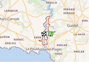
Boucle
Yes
Creation date :
2022-08-25 11:36:58.575
Updated on :
2022-08-25 15:36:36.708
3h58
Difficulty : Medium

FREE GPS app for hiking
 SityTrail
IGN / Geographical institutes
SityTrail Plus
The world is yours!
About
Trail Walking of 9.8 km to be discovered at Brittany, Morbihan, Guidel. This trail is proposed by dcharbonnier.
Description
avec navette!
Photos


Positioning
Country:
France
Region :
Brittany
Department/Province :
Morbihan
Municipality :
Guidel
Location:
Unknown
Start:(Dec)
Start:(UTM)
460536 ; 5291573 (30T) N.
Comments