


Refuge des Sarradets depuis Col des tentes

katiab
User
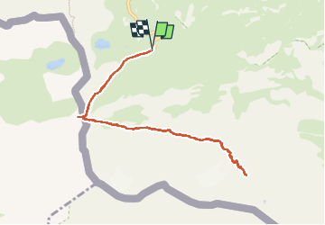

Length
10.1 km

Max alt
2609 m

Uphill gradient
484 m
Km-Effort
16.6 km

Min alt
2198 m

Downhill gradient
482 m
Boucle
Yes
Creation date :
2022-08-24 07:49:37.269
Updated on :
2022-08-30 13:26:42.324
3h47
Difficulty : Medium

FREE GPS app for hiking
 SityTrail
IGN / Geographical institutes
SityTrail Plus
The world is yours!
About
Trail Walking of 10.1 km to be discovered at Occitania, Hautespyrenees, Gavarnie-Gèdre. This trail is proposed by katiab.
Description
Randonnée mythique dans une ambiance haute montagne pas trop difficile jusqu’au refuge. Attention à la traversée du ruisseau (plus de main courante et pieds mouillés assurés, même fin août).
Positioning
Country:
France
Region :
Occitania
Department/Province :
Hautespyrenees
Municipality :
Gavarnie-Gèdre
Location:
Gavarnie
Start:(Dec)
Start:(UTM)
741482 ; 4733187 (30T) N.
Comments