


Sentier de la rivière jaune

francoisecarlier
User
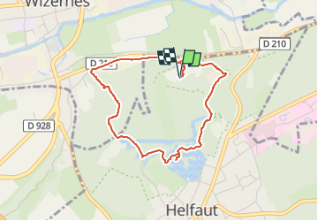

Length
3.5 km

Max alt
98 m

Uphill gradient
81 m
Km-Effort
4.6 km

Min alt
24 m

Downhill gradient
82 m
Boucle
Yes
Creation date :
2022-08-26 08:13:00.0
Updated on :
2022-08-26 09:10:00.771
56m
Difficulty : Very easy

FREE GPS app for hiking
 SityTrail
IGN / Geographical institutes
SityTrail Plus
The world is yours!
About
Trail Walking of 3.5 km to be discovered at Hauts-de-France, Pas-de-Calais, Helfaut. This trail is proposed by francoisecarlier.
Positioning
Country:
France
Region :
Hauts-de-France
Department/Province :
Pas-de-Calais
Municipality :
Helfaut
Location:
Unknown
Start:(Dec)
Start:(UTM)
446360 ; 5617315 (31U) N.
Comments