


Avelange
© OpenStreetMap contributors


3h20
Difficulty : Very difficult


Length
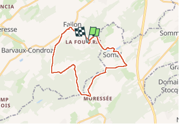
14.2 km
Max alt
331 m
Uphill gradient
369 m
Km-Effort
19.1 km
Min alt
196 m
Downhill gradient
368 m
Boucle
Yes
Creation date :
2022-07-31 05:35:16.0
Updated on :
2022-08-26 16:52:22.998
3h20
Difficulty : Very difficult
FREE GPS app for hiking
 SityTrail
IGN / Geographical institutes
SityTrail Plus
The world is yours!
About
Trail Walking of 14.2 km to be discovered at Wallonia, Namur, Havelange. This trail is proposed by 000062.e45c786fe1e04ca29537bc4d0acf2573.1021.
Description
Mooi
Positioning
Country:
Belgium
Region :
Wallonia
Department/Province :
Namur
Municipality :
Havelange
Location:
Unknown
Start:(Dec)
Start:(UTM)
663873 ; 5578124 (31U) N.
Comments