


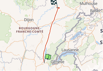
NAV en DA40 LFLP-LFQW

nicolasdresse
User

Length
199 km

Max alt
961 m

Uphill gradient
5177 m
Km-Effort
270 km

Min alt
212 m

Downhill gradient
5858 m
Boucle
No
Creation date :
2022-08-23 15:22:56.0
Updated on :
2023-06-18 13:30:56.315
17h27
Difficulty : Unknown

FREE GPS app for hiking
 SityTrail
IGN / Geographical institutes
SityTrail Plus
The world is yours!
About
Trail Plane of 199 km to be discovered at Auvergne-Rhône-Alpes, Ain, Nantua. This trail is proposed by nicolasdresse.
Positioning
Country:
France
Region :
Auvergne-Rhône-Alpes
Department/Province :
Ain
Municipality :
Nantua
Location:
Unknown
Start:(Dec)
Start:(UTM)
703073 ; 5116253 (31T) N.
Comments