


Verdon

Wolf Résilience
User
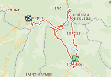

Length
25 km

Max alt
916 m

Uphill gradient
744 m
Km-Effort
35 km

Min alt
634 m

Downhill gradient
726 m
Boucle
No
Creation date :
2022-08-27 07:27:24.881
Updated on :
2022-08-27 12:41:30.866
5h13
Difficulty : Very difficult

FREE GPS app for hiking
 SityTrail
IGN / Geographical institutes
SityTrail Plus
The world is yours!
About
Trail Walking of 25 km to be discovered at Provence-Alpes-Côte d'Azur, Var, Trigance. This trail is proposed by Wolf Résilience.
Positioning
Country:
France
Region :
Provence-Alpes-Côte d'Azur
Department/Province :
Var
Municipality :
Trigance
Location:
Unknown
Start:(Dec)
Start:(UTM)
294088 ; 4848445 (32T) N.
Comments