


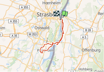
L’élu Marathon 48 km

Alain Williaume
User

Length
48 km

Max alt
153 m

Uphill gradient
338 m
Km-Effort
53 km

Min alt
131 m

Downhill gradient
335 m
Boucle
Yes
Creation date :
2022-08-27 04:36:27.0
Updated on :
2022-08-27 15:10:52.804
9h46
Difficulty : Very difficult

FREE GPS app for hiking
 SityTrail
IGN / Geographical institutes
SityTrail Plus
The world is yours!
About
Trail Walking of 48 km to be discovered at Grand Est, Bas-Rhin, Strasbourg. This trail is proposed by Alain Williaume.
Positioning
Country:
France
Region :
Grand Est
Department/Province :
Bas-Rhin
Municipality :
Strasbourg
Location:
Unknown
Start:(Dec)
Start:(UTM)
411469 ; 5379904 (32U) N.
Comments