


Tour PDD

Papou63patrick
User
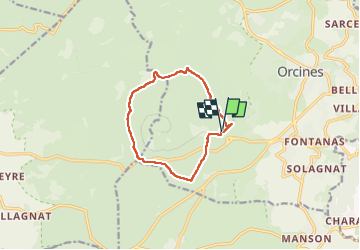

Length
10.2 km

Max alt
1126 m

Uphill gradient
282 m
Km-Effort
14 km

Min alt
892 m

Downhill gradient
285 m
Boucle
Yes
Creation date :
2022-08-09 06:57:05.995
Updated on :
2022-08-27 19:45:03.146
2h29
Difficulty : Medium

FREE GPS app for hiking
 SityTrail
IGN / Geographical institutes
SityTrail Plus
The world is yours!
About
Trail Walking of 10.2 km to be discovered at Auvergne-Rhône-Alpes, Puy-de-Dôme, Orcines. This trail is proposed by Papou63patrick.
Positioning
Country:
France
Region :
Auvergne-Rhône-Alpes
Department/Province :
Puy-de-Dôme
Municipality :
Orcines
Location:
Unknown
Start:(Dec)
Start:(UTM)
498788 ; 5068617 (31T) N.
Comments