


Egenthal Rocher Dabo

vaillantjm
User
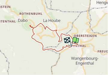

Length
14.6 km

Max alt
744 m

Uphill gradient
621 m
Km-Effort
23 km

Min alt
387 m

Downhill gradient
621 m
Boucle
Yes
Creation date :
2022-08-27 21:43:37.181
Updated on :
2022-08-29 08:36:00.747
4h40
Difficulty : Difficult

FREE GPS app for hiking
 SityTrail
IGN / Geographical institutes
SityTrail Plus
The world is yours!
About
Trail Walking of 14.6 km to be discovered at Grand Est, Bas-Rhin, Wangenbourg-Engenthal. This trail is proposed by vaillantjm.
Positioning
Country:
France
Region :
Grand Est
Department/Province :
Bas-Rhin
Municipality :
Wangenbourg-Engenthal
Location:
Unknown
Start:(Dec)
Start:(UTM)
374206 ; 5388101 (32U) N.
Comments