Trail Walking Villentrois-Faverolles-en-Berry - rando faverolles en berry - Photo
 lecmic
lecmic

User

© OpenStreetMap contributors
Length
Length
18.2 km
Max alt
Max alt
154 m
Uphill gradient
Uphill gradient
166 m
Km-Effort
Km-Effort  
20 km
Min alt
Min alt
102 m
Downhill gradient
Downhill gradient
167 m
Boucle
Boucle
Yes
Creation date :
2022-08-28 05:07:15.869
Updated on :
2022-08-28 08:30:07.554

(0 Reviews)

Walking
Walking
3h17
Difficulty : Easy

Scan this QR Code to open this trail in the SityTrail application

FREE GPS app for hiking

Logo SityTrail SityTrail

IGN / Geographical institutes

Download SityTrail from the App Store Download SityTrail from Google Play

Logo SityTrail SityTrail World

The world is yours!

Download SityTrail from the App Store Download SityTrail from Google Play Download SityTrail on Huawei AppGallery

About

Trail Walking of 18.2 km to be discovered at Centre-Loire Valley, Indre, Villentrois-Faverolles-en-Berry. This trail is proposed by lecmic.

Description

rando Benjamin rabier

Elevation profile

Positioning

Country:
France
Region :
Centre-Loire Valley
Department/Province :
Indre
Municipality :
Villentrois-Faverolles-en-Berry
Location:
Faverolles-en-Berry
Start:(UTM)
379093 ; 5225252 (31T) N.

Trails nearby

Trail Walking Villentrois-Faverolles-en-Berry - villentrois 2019 - Photo
Walking
mimilolo

Walking

Very easy
Villentrois-Faverolles-en-Berry, Centre-Loire Valley, Indre, France
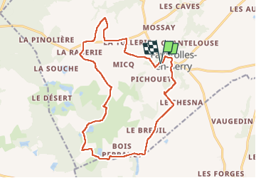
17.8 km | 20 km-effort
3h 13min
No
Trail Walking Villentrois-Faverolles-en-Berry - faverolles en berry - Photo
Walking
lecmic

Walking

Easy
Villentrois-Faverolles-en-Berry, Centre-Loire Valley, Indre, France
17.1 km | 19.6 km-effort
3h 12min
Yes
Trail Walking Villentrois-Faverolles-en-Berry - Étape 2 2023 - Photo
Walking
Pascal Bernaud

Walking

Very difficult
Villentrois-Faverolles-en-Berry, Centre-Loire Valley, Indre, France
21 km | 24 km-effort
6h 59min
No


Close
My subscriptions