


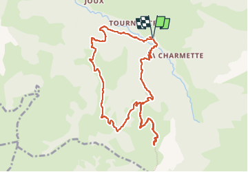
ARAVIS: POINTE D'ORSIERE VARIANTE

djeepee74
User


4h09
Difficulty : Medium

FREE GPS app for hiking
 SityTrail
IGN / Geographical institutes
SityTrail Plus
The world is yours!
About
Trail Walking of 11 km to be discovered at Auvergne-Rhône-Alpes, Upper Savoy, Manigod. This trail is proposed by djeepee74.
Description
BOUCLE... live le 20220829
Montée par la "piste"... descente "épique" par La Balme (mieux vaut éviter d'y descendre par terrain humide ! Inverser alors le sens, voir: https://www.sitytrail.com/fr/trails/3344572-manigod--aravisx-pointe-dxorsiere/ )
Photos


Positioning
Comments