


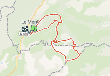
Boucle au départ des chalets

dboon
User


3h11
Difficulty : Medium

FREE GPS app for hiking
 SityTrail
IGN / Geographical institutes
SityTrail Plus
The world is yours!
About
Trail Walking of 10.3 km to be discovered at Grand Est, Vosges, Le Ménil. This trail is proposed by dboon.
Description
Cette randonnée qui comporte des passages assez délicats (bâtons de marche et chaussures adaptées indispensables), passe par trois têtes : La Rouauche, La tête des Renards et la Lochère.
Le début de la rando présente immédiatement un beau dénivelé, histoire de s'échauffer un peu !
Positioning
Comments