


Phalempin 7.5

temjacques
User
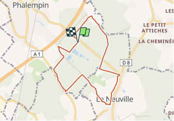

Length
7.5 km

Max alt
73 m

Uphill gradient
68 m
Km-Effort
8.4 km

Min alt
35 m

Downhill gradient
69 m
Boucle
Yes
Creation date :
2022-08-29 10:15:34.244
Updated on :
2022-08-29 10:17:19.96
1h54
Difficulty : Medium

FREE GPS app for hiking
 SityTrail
IGN / Geographical institutes
SityTrail Plus
The world is yours!
About
Trail Walking of 7.5 km to be discovered at Hauts-de-France, Nord, Phalempin. This trail is proposed by temjacques.
Description
Randonnée temps sec
Positioning
Country:
France
Region :
Hauts-de-France
Department/Province :
Nord
Municipality :
Phalempin
Location:
Unknown
Start:(Dec)
Start:(UTM)
502483 ; 5595188 (31U) N.
Comments