


GR400-J2

dudu79
User
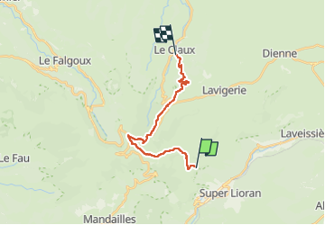

Length
16.2 km

Max alt
1767 m

Uphill gradient
535 m
Km-Effort
25 km

Min alt
1043 m

Downhill gradient
944 m
Boucle
No
Creation date :
2022-08-29 16:06:26.85
Updated on :
2022-08-29 16:07:40.916
0m
Difficulty : Unknown

FREE GPS app for hiking
 SityTrail
IGN / Geographical institutes
SityTrail Plus
The world is yours!
About
Trail Trail of 16.2 km to be discovered at Auvergne-Rhône-Alpes, Cantal, Laveissière. This trail is proposed by dudu79.
Positioning
Country:
France
Region :
Auvergne-Rhône-Alpes
Department/Province :
Cantal
Municipality :
Laveissière
Location:
Unknown
Start:(Dec)
Start:(UTM)
478269 ; 4993725 (31T) N.
Comments