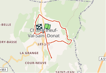
CHÂTEAU NEUF VAL SAINT DONAT . Vieux village , voie Romaine o l s o

RobinMicheline
User GUIDE

Length
7.8 km

Max alt
643 m

Uphill gradient
163 m
Km-Effort
10 km

Min alt
539 m

Downhill gradient
165 m
Boucle
Yes
Creation date :
2022-08-30 07:06:12.958
Updated on :
2022-08-30 10:20:27.784
1h57
Difficulty : Easy

FREE GPS app for hiking
 SityTrail
IGN / Geographical institutes
SityTrail Plus
The world is yours!
About
Trail Walking of 7.8 km to be discovered at Provence-Alpes-Côte d'Azur, Alpes-de-Haute-Provence, Châteauneuf-Val-Saint-Donat. This trail is proposed by RobinMicheline.
Photos


Positioning
Country:
France
Region :
Provence-Alpes-Côte d'Azur
Department/Province :
Alpes-de-Haute-Provence
Municipality :
Châteauneuf-Val-Saint-Donat
Location:
Unknown
Start:(Dec)
Start:(UTM)
736053 ; 4886432 (31T) N.
Comments