


SityTrail - CLD-GM le 30-08-2022

JackPG
User
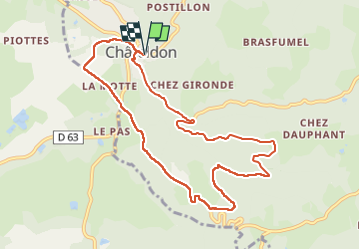

Length
9.9 km

Max alt
573 m

Uphill gradient
355 m
Km-Effort
14.7 km

Min alt
314 m

Downhill gradient
355 m
Boucle
Yes
Creation date :
2022-08-31 05:48:44.55
Updated on :
2022-08-31 05:54:25.676
3h20
Difficulty : Difficult

FREE GPS app for hiking
 SityTrail
IGN / Geographical institutes
SityTrail Plus
The world is yours!
About
Trail Walking of 9.9 km to be discovered at Auvergne-Rhône-Alpes, Puy-de-Dôme, Châteldon. This trail is proposed by JackPG.
Positioning
Country:
France
Region :
Auvergne-Rhône-Alpes
Department/Province :
Puy-de-Dôme
Municipality :
Châteldon
Location:
Unknown
Start:(Dec)
Start:(UTM)
540401 ; 5091565 (31T) N.
Comments