Trail Walking Saint-Cirgues-sur-Couze - 
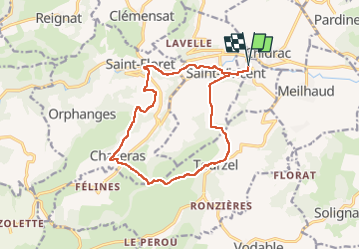
St_Cirgues_St_Floret_Tourzel - Photo
 jagarnier
jagarnier

User GUIDE

© OpenStreetMap contributors
Length
Length
14.4 km
Max alt
Max alt
792 m
Uphill gradient
Uphill gradient
449 m
Km-Effort
Km-Effort  
20 km
Min alt
Min alt
463 m
Downhill gradient
Downhill gradient
449 m
Boucle
Boucle
Yes
Creation date :
2022-08-31 09:35:01.317
Updated on :
2025-01-12 13:44:19.757

(0 Reviews)

Walking
Walking
4h15
Difficulty : Medium

Scan this QR Code to open this trail in the SityTrail application

FREE GPS app for hiking

Logo SityTrail SityTrail

IGN / Geographical institutes

Download SityTrail from the App Store Download SityTrail from Google Play

Logo SityTrail SityTrail Plus

The world is yours!

Download SityTrail from the App Store Download SityTrail from Google Play Download SityTrail on Huawei AppGallery

About

Trail Walking of 14.4 km to be discovered at Auvergne-Rhône-Alpes, Puy-de-Dôme, Saint-Cirgues-sur-Couze. This trail is proposed by jagarnier.

Description

La randonnée suit d'abord la Couze Pavin, puis gravit le plateau vers Chazeras en offrant une belle vue sur le village de Saint-Floret, puis Tourzel, avant de redescendre sur Saint-Cirgues-sur-Couze et son château.

Elevation profile

Photos

Positioning

Country:
France
Region :
Auvergne-Rhône-Alpes
Department/Province :
Puy-de-Dôme
Municipality :
Saint-Cirgues-sur-Couze
Location:
Unknown
Start:(UTM)
511104 ; 5044190 (31T) N.


Close
My subscriptions