


Mateysienne 60km 2000d+

starco
User
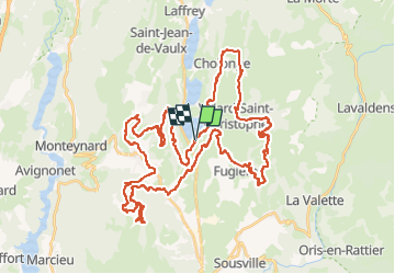

Length
59 km

Max alt
1538 m

Uphill gradient
2079 m
Km-Effort
87 km

Min alt
894 m

Downhill gradient
2082 m
Boucle
Yes
Creation date :
2022-08-31 06:42:02.0
Updated on :
2022-08-31 12:58:29.488
5h29
Difficulty : Difficult

FREE GPS app for hiking
 SityTrail
IGN / Geographical institutes
SityTrail Plus
The world is yours!
About
Trail Mountain bike of 59 km to be discovered at Auvergne-Rhône-Alpes, Isère, Pierre-Châtel. This trail is proposed by starco.
Positioning
Country:
France
Region :
Auvergne-Rhône-Alpes
Department/Province :
Isère
Municipality :
Pierre-Châtel
Location:
Unknown
Start:(Dec)
Start:(UTM)
719255 ; 4983137 (31T) N.
Comments