


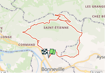
Trail(74) - Kartesis - Chemin Botanique

HG74250
User

Length
10.5 km

Max alt
957 m

Uphill gradient
551 m
Km-Effort
17.8 km

Min alt
444 m

Downhill gradient
551 m
Boucle
Yes
Creation date :
2022-08-31 15:02:14.926
Updated on :
2024-04-30 18:35:56.493
0m
Difficulty : Medium

FREE GPS app for hiking
 SityTrail
IGN / Geographical institutes
SityTrail Plus
The world is yours!
About
Trail Trail of 10.5 km to be discovered at Auvergne-Rhône-Alpes, Upper Savoy, Bonneville. This trail is proposed by HG74250.
Positioning
Country:
France
Region :
Auvergne-Rhône-Alpes
Department/Province :
Upper Savoy
Municipality :
Bonneville
Location:
Unknown
Start:(Dec)
Start:(UTM)
299446 ; 5106434 (32T) N.
Comments