


Tour de Chaudefour

trevezel
User
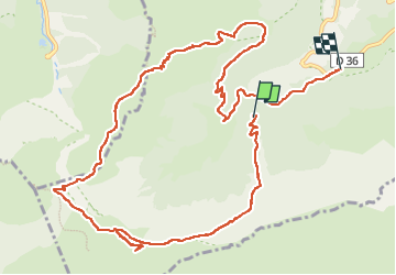

Length
14.1 km

Max alt
1831 m

Uphill gradient
628 m
Km-Effort
23 km

Min alt
1143 m

Downhill gradient
805 m
Boucle
No
Creation date :
2022-08-31 09:59:51.592
Updated on :
2022-08-31 16:50:28.945
6h49
Difficulty : Medium

FREE GPS app for hiking
 SityTrail
IGN / Geographical institutes
SityTrail Plus
The world is yours!
About
Trail Walking of 14.1 km to be discovered at Auvergne-Rhône-Alpes, Puy-de-Dôme, Chambon-sur-Lac. This trail is proposed by trevezel.
Positioning
Country:
France
Region :
Auvergne-Rhône-Alpes
Department/Province :
Puy-de-Dôme
Municipality :
Chambon-sur-Lac
Location:
Unknown
Start:(Dec)
Start:(UTM)
488208 ; 5042444 (31T) N.
Comments