


gr-400-complet-murat-murat

zefreefly
User
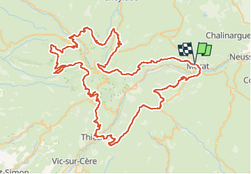

Length
129 km

Max alt
1826 m

Uphill gradient
6071 m
Km-Effort
210 km

Min alt
764 m

Downhill gradient
6070 m
Boucle
Yes
Creation date :
2022-09-01 13:02:01.638
Updated on :
2022-09-01 13:02:01.638

FREE GPS app for hiking
 SityTrail
IGN / Geographical institutes
SityTrail Plus
The world is yours!
About
Trail of 129 km to be discovered at Auvergne-Rhône-Alpes, Cantal, Murat. This trail is proposed by zefreefly.
Points of interest


Positioning
Country:
France
Region :
Auvergne-Rhône-Alpes
Department/Province :
Cantal
Municipality :
Murat
Location:
Murat
Start:(Dec)
Start:(UTM)
489161 ; 4995650 (31T) N.
Comments