
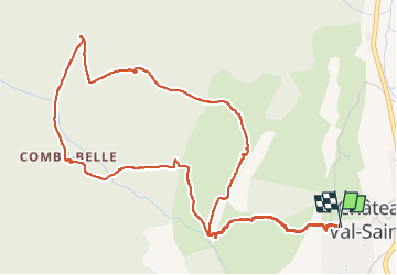
CHÂTEAU NEUF VAL SAINT DONAT. Circuit des bories o l s

RobinMicheline
User GUIDE

Length
6.6 km

Max alt
833 m

Uphill gradient
225 m
Km-Effort
9.6 km

Min alt
613 m

Downhill gradient
226 m
Boucle
Yes
Creation date :
2022-09-02 06:57:31.588
Updated on :
2022-09-02 12:05:18.598
1h57
Difficulty : Medium

FREE GPS app for hiking
 SityTrail
IGN / Geographical institutes
SityTrail Plus
The world is yours!
About
Trail Walking of 6.6 km to be discovered at Provence-Alpes-Côte d'Azur, Alpes-de-Haute-Provence, Châteauneuf-Val-Saint-Donat. This trail is proposed by RobinMicheline.
Photos


Positioning
Country:
France
Region :
Provence-Alpes-Côte d'Azur
Department/Province :
Alpes-de-Haute-Provence
Municipality :
Châteauneuf-Val-Saint-Donat
Location:
Unknown
Start:(Dec)
Start:(UTM)
735691 ; 4886386 (31T) N.
Comments