


20.08.2014 - Port Roch

babeth35
User
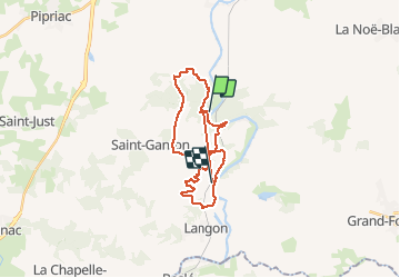

Length
28 km

Max alt
99 m

Uphill gradient
626 m
Km-Effort
36 km

Min alt
1 m

Downhill gradient
633 m
Boucle
No
Creation date :
2014-12-10 00:00:00.0
Updated on :
2020-07-20 16:03:10.929
6h24
Difficulty : Medium

FREE GPS app for hiking
 SityTrail
IGN / Geographical institutes
SityTrail Plus
The world is yours!
About
Trail Walking of 28 km to be discovered at Brittany, Ille-et-Vilaine, Guipry-Messac. This trail is proposed by babeth35.
Positioning
Country:
France
Region :
Brittany
Department/Province :
Ille-et-Vilaine
Municipality :
Guipry-Messac
Location:
Guipry
Start:(Dec)
Start:(UTM)
586346 ; 5291236 (30T) N.
Comments