


st aubin st hilaire st aubin

brunobuj
User
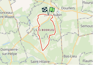

Length
9.4 km

Max alt
194 m

Uphill gradient
97 m
Km-Effort
10.7 km

Min alt
148 m

Downhill gradient
98 m
Boucle
Yes
Creation date :
2022-09-04 07:12:00.709
Updated on :
2022-09-04 09:08:58.872
1h56
Difficulty : Medium

FREE GPS app for hiking
 SityTrail
IGN / Geographical institutes
SityTrail Plus
The world is yours!
About
Trail Walking of 9.4 km to be discovered at Hauts-de-France, Nord, Saint-Aubin. This trail is proposed by brunobuj.
Positioning
Country:
France
Region :
Hauts-de-France
Department/Province :
Nord
Municipality :
Saint-Aubin
Location:
Unknown
Start:(Dec)
Start:(UTM)
565322 ; 5558208 (31U) N.
Comments