


Castans Laviale

Ada11
User GUIDE
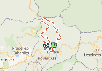

Length
14.2 km

Max alt
1168 m

Uphill gradient
566 m
Km-Effort
22 km

Min alt
650 m

Downhill gradient
580 m
Boucle
Yes
Creation date :
2022-09-04 07:41:50.516
Updated on :
2022-09-04 13:24:08.184
3h48
Difficulty : Very easy

FREE GPS app for hiking
 SityTrail
IGN / Geographical institutes
SityTrail Plus
The world is yours!
About
Trail Walking of 14.2 km to be discovered at Occitania, Aude, Castans. This trail is proposed by Ada11.
Positioning
Country:
France
Region :
Occitania
Department/Province :
Aude
Municipality :
Castans
Location:
Unknown
Start:(Dec)
Start:(UTM)
458024 ; 4806146 (31T) N.
Comments