


challiol cabanes chemin Viallet

Rangabe
User
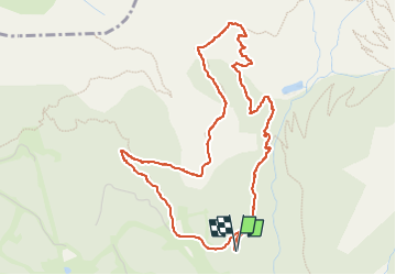

Length
5.5 km

Max alt
2055 m

Uphill gradient
338 m
Km-Effort
10 km

Min alt
1705 m

Downhill gradient
331 m
Boucle
Yes
Creation date :
2022-09-04 13:41:37.985
Updated on :
2022-09-04 19:08:36.725
3h13
Difficulty : Very difficult

FREE GPS app for hiking
 SityTrail
IGN / Geographical institutes
SityTrail Plus
The world is yours!
About
Trail Walking of 5.5 km to be discovered at Provence-Alpes-Côte d'Azur, Hautes-Alpes, Saint-Michel-de-Chaillol. This trail is proposed by Rangabe.
Positioning
Country:
France
Region :
Provence-Alpes-Côte d'Azur
Department/Province :
Hautes-Alpes
Municipality :
Saint-Michel-de-Chaillol
Location:
Unknown
Start:(Dec)
Start:(UTM)
275716 ; 4952771 (32T) N.
Comments