


SityTrail - Rando strenquels 2022

Gpoujade
User
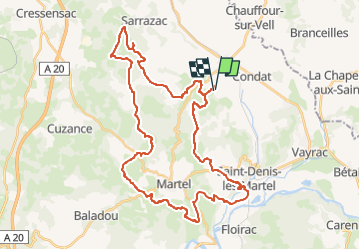

Length
44 km

Max alt
339 m

Uphill gradient
1027 m
Km-Effort
58 km

Min alt
110 m

Downhill gradient
1031 m
Boucle
Yes
Creation date :
2022-09-06 08:31:38.935
Updated on :
2024-02-15 10:42:18.339
3h59
Difficulty : Very difficult

FREE GPS app for hiking
 SityTrail
IGN / Geographical institutes
SityTrail Plus
The world is yours!
About
Trail Mountain bike of 44 km to be discovered at Occitania, Lot, Strenquels. This trail is proposed by Gpoujade.
Description
Rando organisée par le club VTT de Strenquels
Positioning
Country:
France
Region :
Occitania
Department/Province :
Lot
Municipality :
Strenquels
Location:
Unknown
Start:(Dec)
Start:(UTM)
392647 ; 4982015 (31T) N.
Comments