Trail Mountain bike Virton - Les trois éperons barrés  -  Balade_VTT_34kms - Photo

Les trois éperons barrés - Balade_VTT_34kms

 Pascal L
Pascal L

User

© OpenStreetMap contributors
Length
Length
34 km
Max alt
Max alt
364 m
Uphill gradient
Uphill gradient
627 m
Km-Effort
Km-Effort  
42 km
Min alt
Min alt
208 m
Downhill gradient
Downhill gradient
627 m
Boucle
Boucle
Yes
Creation date :
2022-09-05 08:13:01.869
Updated on :
2022-12-01 17:51:00.063

(0 Reviews)

Mountain bike
Mountain bike
3h18
Difficulty : Difficult

Scan this QR Code to open this trail in the SityTrail application

FREE GPS app for hiking

Logo SityTrail SityTrail

IGN / Geographical institutes

Download SityTrail from the App Store Download SityTrail from Google Play

Logo SityTrail SityTrail World

The world is yours!

Download SityTrail from the App Store Download SityTrail from Google Play Download SityTrail on Huawei AppGallery

About

Trail Mountain bike of 34 km to be discovered at Wallonia, Luxembourg, Virton. This trail is proposed by Pascal L.

Description

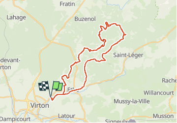
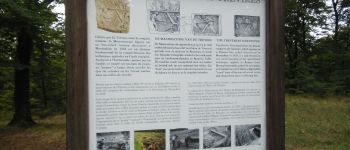
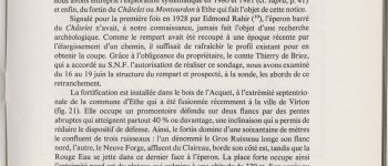
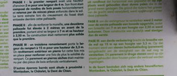
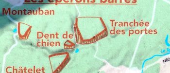
Cette balade intrépide vous conduit sur trois éperons barrés : le "Châtelet" à Ethe, la "Dent de Chien" à Buzenol et la "Tranchée des Portes" à Etalle. Il s'agit d'un système de défense vaste datant de l'âge du fer (époque protohistorique, celtique, gauloise) qui comprenait aussi le célèbre promontoire de "Montauban" de Buzenol.

Départ/Retour: Virton (Pierrard)
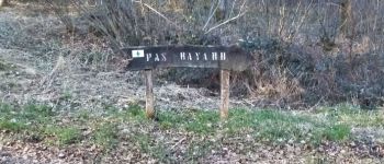
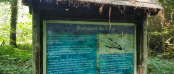
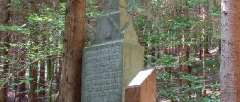
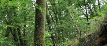
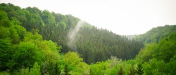
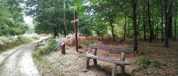
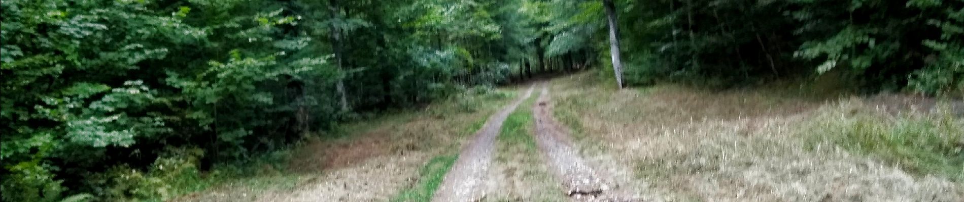
Endroits de passage : Ravel (ligne 155), Belmont, Rue de Belle Vue, le Chenoi, Ruisseau du Chou, Ourdon, Ravel (ligne 155), Bois de l'Acquêt, Montourdon et sa grotte, la Neuve Forge et son ruisseau, le ruisseau la Rouge Eau, la Dent de Chien (escalade et exploration), Têtes des Ronces, Bois d'Etalle, pompages et réservoir, Tranchée des Portes (exploration), Haie de Han de St-Léger, La Cuisine Sauvage, Vertes Voies, Croix Célestin, Bois d'Ahérée, Bois de St-Léger, Croix la Cloutière, Voie des Bourriques, Croix Renson, pont et ruisseau de la Neuve Forge, vallée et ruisseau de Laclaireau, Ethe, Ravel (ligne 155).

Vidéo: https://vimeo.com/747303091   (La Rouge Eau à la Cuisine Sauvage)

PI:
1) Châtelet : https://www.sitytrail.com/fr/poi/20971328-virton--le-chatelet-a-ethe
2) Dent de Chien : https://www.sitytrail.com/fr/poi/21039815-etalle--dent-de-chien-a-buzenol/
3) Tranchée des Portes : https://www.sitytrail.com/fr/poi/20973435-etalle--la-tranchee-des-portes-a-etalle/
4) Montauban : https://www.sitytrail.com/fr/poi/20730527-etalle--site-galloxromain-et-cron-de-montauban

Ref.
- https://www.virton.be/loisirs/culture/breve-histoire-de-virton
- https://www.facebook.com/Cuisine-Sauvage-A-la-Rouge-Eau-1517051368597020/
- http://biodiversite.wallonie.be/fr/2373-vallee-de-la-rouge-eau.html?IDD=251660568&IDC=1881

(2022.09.05)

Elevation profile

Photos

85 photos in total. Please click on a photo to see them all in the gallery.

Points of interest

Point of interest Virton - Pas Bayard à Virton - Photo
Pascal L
Point of interest Virton - Ruisseau du Cron - Photo
Pascal L
Point of interest Virton - Unnamed POI - Photo
Pascal L
VIRTON 
Point of interest Virton - Croix Renson - Photo
Pascal L
VIRTON 
Point of interest Saint-Léger - Croix du Taureau - Photo
Pascal L
SAINT-LÉGER 
Point of interest Virton - Le Châtelet à Ethe - Photo
Pascal L
Point of interest Saint-Léger - Croix la Cloutière - Photo
Pascal L
SAINT-LÉGER 
Point of interest Étalle - Dent de Chien à Buzenol - Photo
Pascal L

Positioning

Country:
Belgium
Region :
Wallonia
Department/Province :
Luxembourg
Municipality :
Virton
Location:
Virton
Start:(UTM)
684243 ; 5494502 (31U) N.

Trails nearby

Trail Walking Virton - RB-Lu-17_Ethe_via-var-1-et-2-et-3 - Photo
Walking
PRO

Walking

Very easy
(3)
Virton, Wallonia, Luxembourg, Belgium
29 km | 35 km-effort
7h 33min
Yes
Trail Mountain bike Virton - T2019-06-16-16-47 - Photo
Mountain bike
Pascal L

Mountain bike

Easy
(1)
Virton, Wallonia, Luxembourg, Belgium
21 km | 26 km-effort
1h 40min
Yes
Trail Walking Virton - GAUME Balade  naturelle et historique - Photo
Walking
julucasi

Walking

Very easy
(1)
Virton, Wallonia, Luxembourg, Belgium
5.2 km | 6.8 km-effort
1h 16min
Yes
Trail On foot Virton - La Bajocienne - Photo
On foot
GUIDE+

On foot

Easy
(1)
Virton, Wallonia, Luxembourg, Belgium
11 km | 14.5 km-effort
3h 17min
Yes
Trail On foot Virton - 12479951-Entre village et fruits - Photo
On foot
GUIDE
DUPONT Rita

On foot

Easy
Virton, Wallonia, Luxembourg, Belgium
6.4 km | 7.7 km-effort
1h 45min
Yes
Trail Walking Virton - RB-Lu-17_Ethe_via-racc - Photo
Walking
PRO

Walking

Very easy
Virton, Wallonia, Luxembourg, Belgium
15.6 km | 19.3 km-effort
4h 8min
Yes
Trail Walking Virton - RB-Lu-17_Ethe - Photo
Walking
PRO

Walking

Very easy
Virton, Wallonia, Luxembourg, Belgium
22 km | 28 km-effort
5h 55min
Yes
Trail Mountain bike Virton - Autour de Tintigny  -  Balade_VTT_54Kms - Photo
Mountain bike
Pascal L

Mountain bike

Very difficult
Virton, Wallonia, Luxembourg, Belgium
54 km | 64 km-effort
4h 25min
Yes
Trail Mountain bike Virton - Monquintin  -  Balade_VTT_22Kms - Photo
Mountain bike
Pascal L

Mountain bike

Medium
Virton, Wallonia, Luxembourg, Belgium
22 km | 26 km-effort
1h 48min
Yes


Close
My subscriptions