


Boucle au départ de Lacaune

pidjam
User
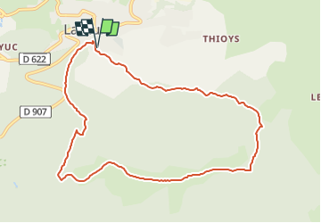

Length
10.2 km

Max alt
1178 m

Uphill gradient
409 m
Km-Effort
15.7 km

Min alt
807 m

Downhill gradient
408 m
Boucle
Yes
Creation date :
2022-09-07 07:07:05.99
Updated on :
2022-09-07 07:07:43.276
3h34
Difficulty : Difficult

FREE GPS app for hiking
 SityTrail
IGN / Geographical institutes
SityTrail Plus
The world is yours!
About
Trail Walking of 10.2 km to be discovered at Occitania, Tarn, Lacaune. This trail is proposed by pidjam.
Points of interest


Positioning
Country:
France
Region :
Occitania
Department/Province :
Tarn
Municipality :
Lacaune
Location:
Unknown
Start:(Dec)
Start:(UTM)
475228 ; 4839081 (31T) N.
Comments