


ITALIE BELLINO La Batayolle

RobinMicheline
User GUIDE
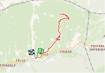

Length
9.2 km

Max alt
2049 m

Uphill gradient
480 m
Km-Effort
15.6 km

Min alt
1587 m

Downhill gradient
476 m
Boucle
Yes
Creation date :
2022-09-07 07:37:24.22
Updated on :
2022-09-10 15:21:11.838
3h42
Difficulty : Medium

FREE GPS app for hiking
 SityTrail
IGN / Geographical institutes
SityTrail Plus
The world is yours!
About
Trail Walking of 9.2 km to be discovered at Piemont, Cuneo, Bellino. This trail is proposed by RobinMicheline.
Photos

Positioning
Country:
Italy
Region :
Piemont
Department/Province :
Cuneo
Municipality :
Bellino
Location:
Unknown
Start:(Dec)
Start:(UTM)
342583 ; 4938326 (32T) N.
Comments