


Ochey vau Dermont

manginpascale
User
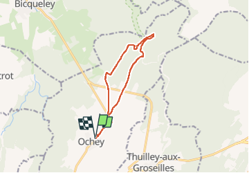

Length
10.5 km

Max alt
321 m

Uphill gradient
133 m
Km-Effort
12.3 km

Min alt
251 m

Downhill gradient
127 m
Boucle
Yes
Creation date :
2022-09-08 06:56:37.878
Updated on :
2022-09-08 08:32:13.664
1h33
Difficulty : Very easy

FREE GPS app for hiking
 SityTrail
IGN / Geographical institutes
SityTrail Plus
The world is yours!
About
Trail Trail of 10.5 km to be discovered at Grand Est, Meurthe-et-Moselle, Ochey. This trail is proposed by manginpascale.
Positioning
Country:
France
Region :
Grand Est
Department/Province :
Meurthe-et-Moselle
Municipality :
Ochey
Location:
Unknown
Start:(Dec)
Start:(UTM)
717056 ; 5385337 (31U) N.
Comments