


Port aux Cerises

Lucquiaud
User
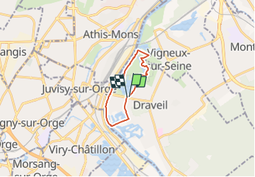

Length
7.8 km

Max alt
42 m

Uphill gradient
54 m
Km-Effort
8.5 km

Min alt
28 m

Downhill gradient
57 m
Boucle
Yes
Creation date :
2022-09-08 09:11:42.488
Updated on :
2022-09-09 12:47:29.098
2h32
Difficulty : Easy

FREE GPS app for hiking
 SityTrail
IGN / Geographical institutes
SityTrail Plus
The world is yours!
About
Trail On foot of 7.8 km to be discovered at Ile-de-France, Essonne, Draveil. This trail is proposed by Lucquiaud.
Positioning
Country:
France
Region :
Ile-de-France
Department/Province :
Essonne
Municipality :
Draveil
Location:
Unknown
Start:(Dec)
Start:(UTM)
455695 ; 5392914 (31U) N.
Comments