


Rochepot n6 table orientât

iznogud
User
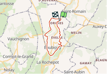

Length
9.8 km

Max alt
564 m

Uphill gradient
287 m
Km-Effort
13.6 km

Min alt
332 m

Downhill gradient
288 m
Boucle
Yes
Creation date :
2022-09-08 15:13:54.0
Updated on :
2022-09-08 16:52:50.734
1h38
Difficulty : Unknown

FREE GPS app for hiking
 SityTrail
IGN / Geographical institutes
SityTrail Plus
The world is yours!
About
Trail Running of 9.8 km to be discovered at Bourgogne-Franche-Comté, Côte-d'Or, Baubigny. This trail is proposed by iznogud.
Positioning
Country:
France
Region :
Bourgogne-Franche-Comté
Department/Province :
Côte-d'Or
Municipality :
Baubigny
Location:
Unknown
Start:(Dec)
Start:(UTM)
628651 ; 5205483 (31T) N.
Comments