


Maubeuge HIRSON

svp59
User
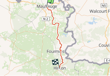

Length
58 km

Max alt
261 m

Uphill gradient
670 m
Km-Effort
66 km

Min alt
133 m

Downhill gradient
611 m
Boucle
No
Creation date :
2014-12-10 00:00:00.0
Updated on :
2014-12-10 00:00:00.0
3h49
Difficulty : Medium

FREE GPS app for hiking
 SityTrail
IGN / Geographical institutes
SityTrail Plus
The world is yours!
About
Trail Cycle of 58 km to be discovered at Hauts-de-France, Nord, Maubeuge. This trail is proposed by svp59.
Description
VTC
Positioning
Country:
France
Region :
Hauts-de-France
Department/Province :
Nord
Municipality :
Maubeuge
Location:
Unknown
Start:(Dec)
Start:(UTM)
568832 ; 5569449 (31U) N.
Comments