


Boucle au départ de Bondoufle

les randos d'Olivier
partout a pied et en moto
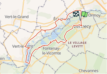

Length
18.8 km

Max alt
87 m

Uphill gradient
176 m
Km-Effort
21 km

Min alt
44 m

Downhill gradient
177 m
Boucle
Yes
Creation date :
2022-09-09 05:36:58.449
Updated on :
2023-02-26 16:35:32.209
5h08
Difficulty : Very difficult

FREE GPS app for hiking
 SityTrail
IGN / Geographical institutes
SityTrail Plus
The world is yours!
About
Trail Walking of 18.8 km to be discovered at Ile-de-France, Essonne, Mennecy. This trail is proposed by les randos d'Olivier.
Points of interest


Positioning
Country:
France
Region :
Ile-de-France
Department/Province :
Essonne
Municipality :
Mennecy
Location:
Unknown
Start:(Dec)
Start:(UTM)
458189 ; 5379894 (31U) N.
Comments