


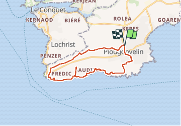
St Mathieu plougonvelin

xcreator
User

Length
13.1 km

Max alt
60 m

Uphill gradient
162 m
Km-Effort
15.2 km

Min alt
8 m

Downhill gradient
159 m
Boucle
Yes
Creation date :
2022-09-05 12:19:03.319
Updated on :
2022-09-09 09:34:21.507
3h50
Difficulty : Difficult

FREE GPS app for hiking
 SityTrail
IGN / Geographical institutes
SityTrail Plus
The world is yours!
About
Trail Walking of 13.1 km to be discovered at Brittany, Finistère, Plougonvelin. This trail is proposed by xcreator.
Positioning
Country:
France
Region :
Brittany
Department/Province :
Finistère
Municipality :
Plougonvelin
Location:
Unknown
Start:(Dec)
Start:(UTM)
372670 ; 5355998 (30U) N.
Comments