


20220909 Pradelles-Chelard Eveque

Jeanclaudebic
User
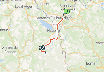

Length
23 km

Max alt
1235 m

Uphill gradient
486 m
Km-Effort
29 km

Min alt
899 m

Downhill gradient
519 m
Boucle
No
Creation date :
2022-09-09 06:11:56.152
Updated on :
2022-09-23 08:11:06.457
6h20
Difficulty : Very difficult

FREE GPS app for hiking
 SityTrail
IGN / Geographical institutes
SityTrail Plus
The world is yours!
About
Trail Walking of 23 km to be discovered at Auvergne-Rhône-Alpes, Haute-Loire, Pradelles. This trail is proposed by Jeanclaudebic.
Positioning
Country:
France
Region :
Auvergne-Rhône-Alpes
Department/Province :
Haute-Loire
Municipality :
Pradelles
Location:
Unknown
Start:(Dec)
Start:(UTM)
569868 ; 4957735 (31T) N.
Comments