


Anor

BOUMA
User
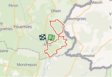

Length
23 km

Max alt
271 m

Uphill gradient
288 m
Km-Effort
27 km

Min alt
208 m

Downhill gradient
285 m
Boucle
Yes
Creation date :
2022-09-10 05:56:02.299
Updated on :
2022-09-10 11:00:27.116
4h27
Difficulty : Medium

FREE GPS app for hiking
 SityTrail
IGN / Geographical institutes
SityTrail Plus
The world is yours!
About
Trail Nordic walking of 23 km to be discovered at Hauts-de-France, Nord, Anor. This trail is proposed by BOUMA.
Positioning
Country:
France
Region :
Hauts-de-France
Department/Province :
Nord
Municipality :
Anor
Location:
Unknown
Start:(Dec)
Start:(UTM)
578856 ; 5538283 (31U) N.
Comments